NEBC Connector
NEBC Connector Project
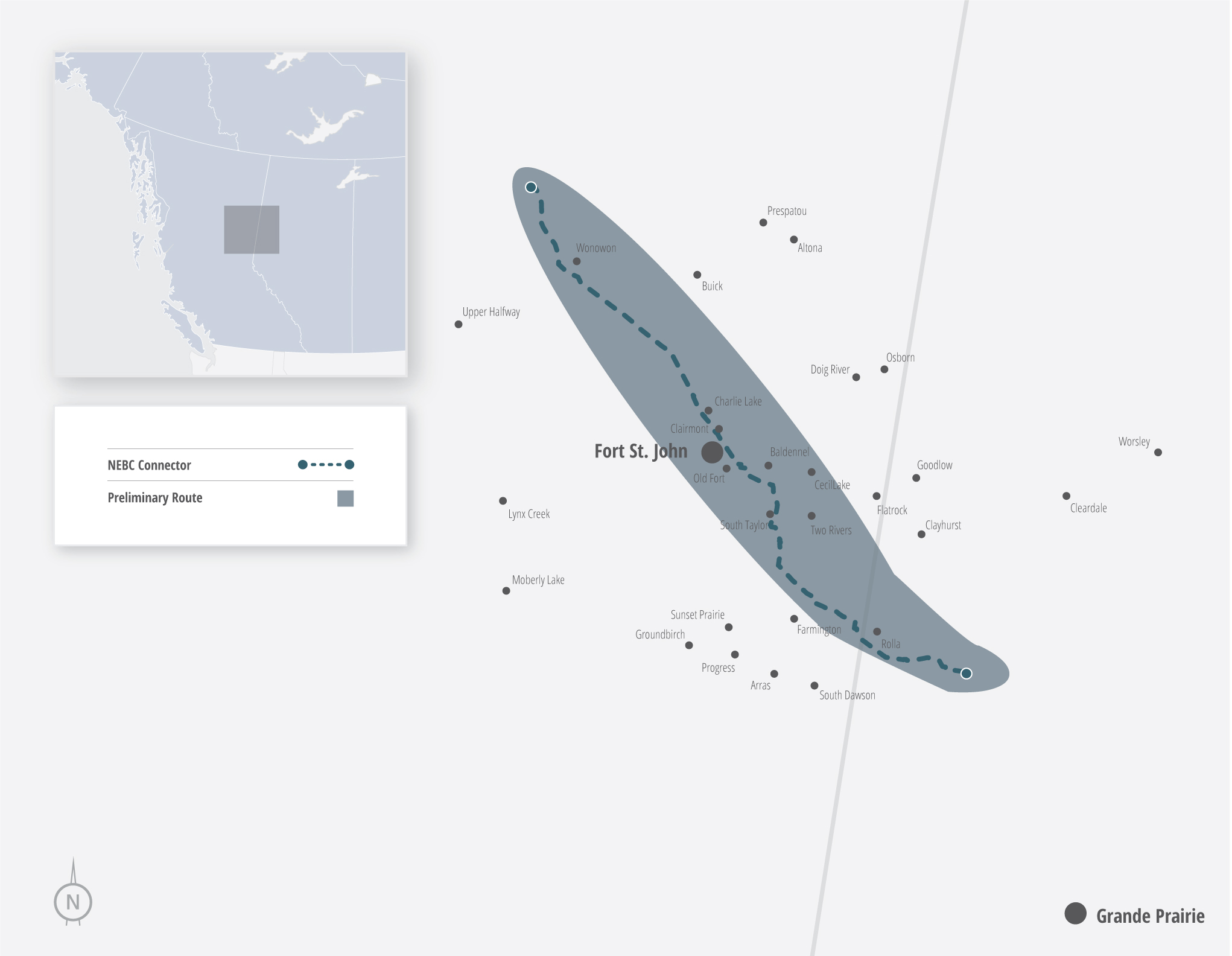
NorthRiver Midstream Inc. is proposing to construct and operate the NEBC Connector to connect British Columbia’s Montney Resource to downstream markets.
The NEBC Connector consists of two parallel small diameter pipelines (between 8”-12”) and approximately 213 km in length. Of the approximately 213 km, 190 km will be in British Columbia and the remaining 23 km will be in Alberta.
It is anticipated that the pipelines will transport condensate (C5+) and natural gas liquids (NGL) (C3+) from NorthRiver Midstream Inc.’s Highway Liquids Hub, northwest of Wonowon, B.C., to the Gordondale area of Alberta.
Contacts
Bag Service 6180, Mile 53 Alaska Highway
Fort St. John, B.C., V1J 4H7
Phone: 250.262.3613
Email: Regulatory@nrm.ca
- Project Type: Pipeline
- Products Shipped: Condensate (C5+) and Natural Gas Liquids (C3+)
- Status: Proposed
- Length: Approximately 213 km
- Pipe Size: Small diameter pipe ranging from 8″-12″
Project information
Project Timeline
NorthRiver Midstream began early Indigenous, landowner and stakeholder engagement in Q2 2020. Subject to a final investment decision to proceed with the Project, construction will be complete and the project placed into service in Q2 of 2027.
Q2 2020
Begin early Indigenous and stakeholder (including landowner) engagement
Q3 2020
Commence survey, environmental field studies and community-led traditional land resource use assessments
Q3 2021
Complete environmental field studies, including archaeology assessments
Q4 2021
File Project Application with the Canada Energy Regulator
Q4 2023
Canada Energy Regulator issued a Certificate of Public Convenience and Necessity, providing final federal approval
Q1 2025
BC approval was received on January 17, 2025. AB approval was received on February 3, 2025.
Q2 2025
Positive final investment decision reached
Current Status
NEBC Connector expected be in service H1 2027
Map
Project route
NorthRiver Midstream strives to engage early and often in an open manner with Indigenous communities, landowners and other interested stakeholders.
Should you have any questions or concerns about the project, please contact Regulatory@nrm.ca or 587-747-6500.
For more information, visit the Canada Energy Regulator project page.
Detailed Route Process
As NorthRiver has obtained a Certificate and Order from the CER for the NEBC Connector Project, it must now submit and obtain approval of its Plan, Profile, and Book of Reference (PPBoR) from the CER. As such, NorthRiver must serve a notice on all owners of lands proposed to be acquired, leased, taken or used, insofar as they can be determined. NorthRiver must also publish a notice in a local newspaper or publication.
Plan and Profile: This document is a drawing of the pipeline as seen from above (the aerial view) and from the side (profile view). It shows the exact proposed location of the pipeline across the parcels of land along its entire route.
- Plan and Profile Sheet 1
- Plan and Profile Sheet 2
- Plan and Profile Sheet 3
- Plan and Profile Sheet 4
- Plan and Profile Sheet 5
- Plan and Profile Sheet 6
- Plan and Profile Sheet 7
- Plan and Profile Sheet 8
- Plan and Profile Sheet 9
- Plan and Profile Sheet 10
- Plan and Profile Sheet 11
- Plan and Profile Sheet 12
- Plan and Profile Sheet 13
- Plan and Profile Sheet 14
- Plan and Profile Sheet 15
- Plan and Profile Sheet 16
- Plan and Profile Sheet 17
- Plan and Profile Sheet 18
- Plan and Profile Sheet 19
- Plan and Profile Sheet 20
- Plan and Profile Sheet 21
- Plan and Profile Sheet 22
- Plan and Profile Sheet 23
- Plan and Profile Sheet 24
- Plan and Profile Sheet 25
- Plan and Profile Sheet 26
- Plan and Profile Sheet 27
- Plan and Profile Sheet 28
- Plan and Profile Sheet 29
- Plan and Profile Sheet 30
- Plan and Profile Sheet 31
- Plan and Profile Sheet 32
- Plan and Profile Sheet 33
- Plan and Profile Sheet 34
- Plan and Profile Sheet 35
- Plan and Profile Sheet 36
- Plan and Profile Sheet 37
- Plan and Profile Sheet 38
- Plan and Profile Sheet 39
- Plan and Profile Sheet 40
- Plan and Profile Sheet 41
- Plan and Profile Sheet 42
- Plan and Profile Sheet 43
- Plan and Profile Sheet 44
- Plan and Profile Sheet 45
- Plan and Profile Sheet 46
- Plan and Profile Sheet 47
- Plan and Profile Sheet 48
- Plan and Profile Sheet 49
- Plan and Profile Sheet 50
- Plan and Profile Sheet 51
- Plan and Profile Sheet 52
- Plan and Profile Sheet 53
- Plan and Profile Sheet 54
- Plan and Profile Sheet 55
- Plan and Profile Sheet 56
- Plan and Profile Sheet 57
- Plan and Profile Sheet 58
- Plan and Profile Sheet 59
- Plan and Profile Sheet 60
- Plan and Profile Sheet 61
- Plan and Profile Sheet 62
- Plan and Profile Sheet 63
Book of Reference: This document identifies the lands and the names of the owners and occupants of the lands in question. It shows the dimensions (length, width, and total area) of the right-of-way required for the pipeline.
Public Notice: The notice will include details about the proposed route, such as maps, property sketches, and detailed measurements of the right-of-way.